- Summary
- Table Of Content
- Methodology
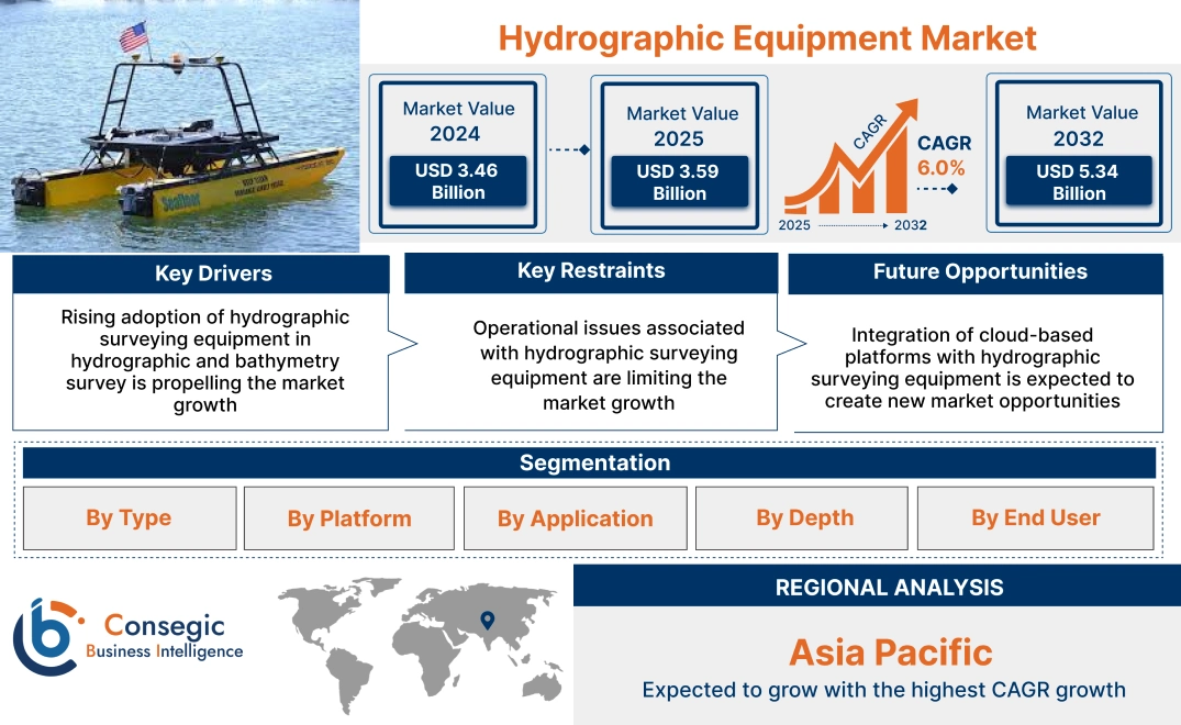
Hydrographic Equipment Market Size:
Hydrographic Equipment Market size is estimated to reach over USD 5.34 Billion by 2032 from a value of USD 3.46 Billion in 2024 and is projected to grow by USD 3.59 Billion in 2025, growing at a CAGR of 6.0% from 2025 to 2032.
Hydrographic Equipment Market Scope & Overview:
Hydrographic equipment is used to measure and map underwater terrain and includes sonar systems, echo sounders, GPS devices, and autonomous underwater vehicles (AUVs) by producing detailed bathymetric charts. The equipment provides crucial data for mapping water depths, underwater features, and seabed composition. The equipment provides accurate data for creating nautical charts, which are essential for safe navigation, particularly for large ships. Moreover, it enables monitoring of marine habitats and tracking changes in underwater environments. Accurate hydrographic data helps predict and mitigate the impacts of natural disasters such as tsunamis, hurricanes, and coastal flooding.
Hydrographic Equipment Market Dynamics - (DRO) :
Key Drivers:
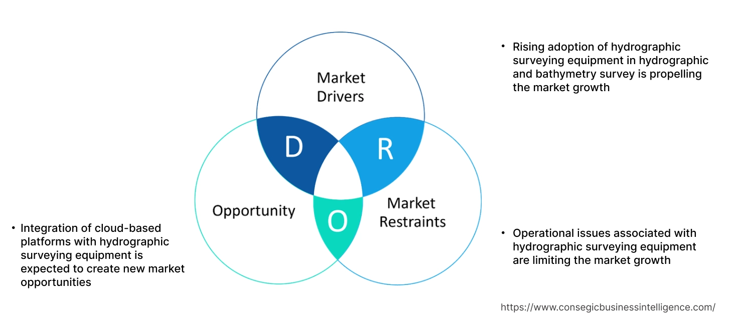
Rising adoption of hydrographic surveying equipment in hydrographic and bathymetry survey is propelling the market growth
Hydrographic surveying is the measurement and description of marine and maritime environmental features, including shorelines, seabed, and riverbed. It is essential for navigation, marine construction, dredging, offshore oil and gas exploration, and coastal zone management. Bathymetric surveys, a type of hydrographic survey, focus specifically on measuring water depth and mapping underwater topography. The collected data from hydrographic surveys is used in navigation, marine construction, offshore oil and gas, environmental monitoring, and scientific research.
- For instance, in January 2025, INS Sarvekshak, Indian Navy’s hydrographic survey ship, successfully completed a major hydrographic survey in Mauritius, covering an extensive area of over 25,000 square nautical miles.
Thus, the aforementioned factors are boosting the usage of equipment in hydrographic and bathymetry survey, in turn, driving the hydrographic equipment market growth.
Key Restraints:
Operational issues associated with hydrographic surveying equipment are limiting the market growth
The environmental factors including rough seas, low visibility, and severe weather conditions significantly impact data collection and crew safety. Moreover, turbidity, currents, tides, and salinity affect the performance of sonar and other equipment, leading to inaccurate data. Furthermore, obstacles including rocks, shipwrecks, and debris complicate survey paths and affect data accuracy.
Additionally, malfunctions lead to data loss and delays, requiring immediate repairs or replacements. Further, outdated equipment and specifications hinder the ability to adapt to new technologies and methodologies. Therefore, the market analysis shows that the aforementioned factors are restraining the hydrographic equipment market demand.
Future Opportunities :
Integration of cloud-based platforms with hydrographic surveying equipment is expected to create new market opportunities
Integrating hydrographic equipment with cloud-based platforms enables real-time data analysis, improved mapping accuracy, and efficient data processing. Cloud platforms provide scalable and secure storage for large hydrographic datasets. Cloud-based tools enable rapid analysis of survey data, allowing for immediate insights and informed decision-making. Cloud platforms offer easy sharing and collaboration among hydrographic teams and stakeholders. Cloud-based hydrographic software solutions offer access to powerful tools without the need for expensive hardware and software licenses.
- For instance, in July 2024, Terradepth and Hypack collaborated to enable surveyors to run Hypack's software directly in the cloud through Terradepth's Absolute Ocean platform. This collaboration aims to streamline the hydrographic survey workflow.
Thus, the ongoing advancements in technologies and their integration with hydrographic surveying equipment are projected to drive hydrographic equipment market opportunities during the forecast period.
Hydrographic Equipment Market Segmental Analysis :
By Type:
Based on the type, the market is segmented into positioning systems, optical systems, sensing systems, profilers, software, and others.
Trends in the Type:
- Rising demand in positioning systems for accurate mapping of underwater features and ensuring safe navigation by providing precise geo-referencing of survey data.
- Increasing adoption of remote optical systems techniques, including satellite-based and airborne systems, to observe and map surface water features and water quality is boosting the hydrographic equipment market size.
The sensing systems segment accounted for the largest revenue in the hydrographic equipment market share in 2024.
- Hydrographic sensing systems include sonar, LiDAR, tide gauges, and pressure sensors, for underwater mapping, environmental monitoring, and nautical chart production.
- Sonar is used to measure water depth and create bathymetric profiles while LiDAR is used to create 3D point clouds of the water surface and adjacent land areas.
- Moreover, tide gauges measure water levels and tidal cycles and pressure sensors measure water depth and pressure variations.
- For instance, in March 2024, Kongsberg Discovery launched Seapath 385 for hydrographic surveying. Seapath 385 combines inertial technology and processing algorithms with multi-frequency GEO satellite signals, Beidou, GPS, Galileo, GLONASS, and QZSS.
- Therefore, the wide applications of sensing systems are boosting the hydrographic equipment market growth.
The software segment is expected to register the fastest CAGR during the forecast period.
- Hydrographic software is used for collecting, processing, and analyzing data from underwater surveys, which enables the creation of charts, maps, and models.
- The software performs various functions including monitoring the quality of data as it's collected, visualizing the vessel's position and survey progress in real-time, and automating survey tasks and streamlining workflows.
- Moreover, the software also assists in removing noise and errors from the collected data, applying corrections for factors such as sound velocity, water depth, tide, and identifying and removing inaccurate data points.
- For instance, in June 2022, Eye4Software launched latest version of professional hydrographic survey package, Hydromagic version 10.0. The software assists in mapping of the bottom of rivers, ponds, reservoirs, and oceans in 3D.
- Thus, the market analysis depicts that the aforementioned factors are anticipated to propel the hydrographic equipment market trends during the forecast period.
By Platform:
Based on the platform, the market is segmented into surface vessels, USVs and UUVs, and aircraft.
Trends in the Platform:
- Rising adoption of aircraft to map large areas quickly and efficiently is driving the hydrographic equipment market size.
- Increasing trend in usage of aircraft to cover areas that are difficult to reach by traditional survey vessels.
The USVs and UUVs segment accounted for the largest revenue of in the hydrographic equipment market share in 2024.
- Unmanned surface vehicles (USVs) and unmanned underwater vehicles (UUVs) enable efficient and cost-effective data collection for mapping water bodies and seabed.
- UUVs are underwater vehicles that can operate autonomously or remotely, enabling exploration and data collection in underwater environments. Meanwhile, USVs are watercraft that operate on the surface without a crew, providing a safer, faster, and more cost-effective way to collect data.
- For instance, in June 2022, SEA-KIT launched new H-class USV for ocean survey. The H-class features a composite hull for higher transit speeds and accommodate a range of sensors.
- Therefore, the applications of USVs and UUVs in hydrographic surveying are boosting the hydrographic equipment market demand.
The surface vessels segment is expected to register the fastest CAGR during the forecast period.
- The surface vessels are equipped with specialized equipment, such as multi-beam echo sounders and side-scan sonar, to collect data on water depth, seafloor topography, and the presence of objects.
- For instance, in April 2024, Sea Machines launched SELKIE unscrewed surface vessel. The vessel offers hydrographic surveying and offshore asset inspection.
- Thus, the aforementioned factors are expected to boost the hydrographic equipment market trends during the forecast period.
By Application:
Based on the application, the market is segmented into hydrographic and bathymetry survey, port and harbor management, offshore oil and gas survey, cable and pipeline route survey, and others.
Trends in the Application:
- Rising demand for hydrographic surveying equipment for evaluating the suitability of the seabed for pipeline installation and ensuring that the pipeline route is safe and environmentally sound.
- Increasing trend in adoption of hydrographic equipment to support the safe navigation of vessels and efficient management of marine infrastructure.
The offshore oil and gas survey segment accounted for the largest revenue share of in the market in 2024.
- Hydrographic surveys are crucial for offshore oil and gas activities, providing essential data for exploration, drilling, pipeline placement, and infrastructure maintenance, ensuring safe and efficient operations.
- Moreover, precise surveys are essential for planning and laying pipelines across the seabed, ensuring safe and efficient transport of oil and gas.
- For instance, in September 2023, Guardian Geomatics, a provider of marine survey solutions to the oil & gas industry, was acquired by Reach Subsea. This acquisition is a part of Reach Subsea’s global expansion.
- Therefore, hydrographic equipment market analysis depicts that the wide applications of hydrographic survey in oil and gas surveying are driving the market growth.
The port and harbor management segment is expected to register the fastest CAGR during the forecast period.
- Hydrographic surveys provide accurate information about water depths, seabed features, and potential risks, ensuring safe navigation for ships entering and leaving ports. Hydrographic data is essential for planning and designing port infrastructure.
- Moreover, understanding water levels, currents, and tidal patterns allows for efficient port operations, including optimizing vessel traffic, loading/unloading procedures, and resource allocation.
- Thus, the market analysis depicts that the aforementioned factors are anticipated to boost the market during the forecast period.
By Depth:
Based on the depth, the market is segmented into shallow water and deep water.
Trends in the Depth:
- Rising demand of hydrographic surveying equipment for deep water surveying to map the unexplored seabed.
- Increasing trend in adoption of hydrographic surveying equipment for shallow water surveying for port and harbor management is propelling the market.
The shallow segment accounted for the largest revenue share of in the market in 2024.
- In shallow water hydrographic surveys, equipment like multi-beam echo sounders (MBES), side-scan sonar, and LiDAR are used to map the seabed and water depth.
- MBES emit acoustic waves in a fan shape to map the seabed and calculate water depth, essential for creating bathymetric charts. Meanwhile, side-scan sonar uses sonar to create images of the seabed, helping to locate underwater obstacles, wrecks, and other features.
- For instance, in February 2025, Australia gave shallow water multi-beam echo sounder to Sri Lanka Navy Hydrographic Service (SLNHS) to boost the island nation’s water mapping capabilities. The device supports production of high-precision nautical charts, ensuring safer maritime navigation.
- Therefore, the rising adoption of hydrographic surveying in shallow water is boosting the hydrographic equipment market expansion.
The deep segment is expected to register the fastest CAGR during the forecast period.
- Hydrographic surveys in deep water are essential for creating detailed maps of the seabed, including its geological features, topography, and potential hazards like wrecks and rocks.
- The data collected during hydrographic surveys is used to create nautical charts, which are vital for maritime navigation, providing information on water depths, channels, and potential obstacles.
- Thus, the hydrographic equipment market analysis depicts that the aforementioned factors are expected to boost the market during the forecast period.
By End User:
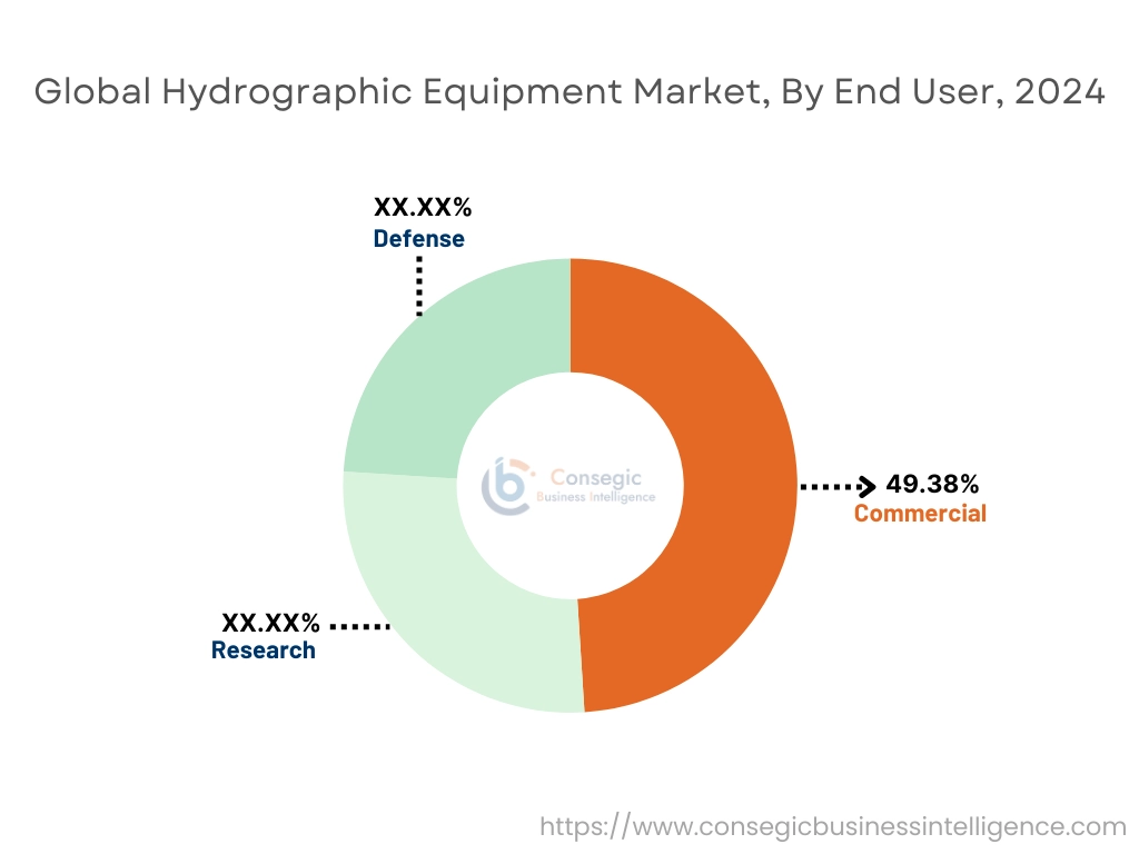
Based on the end user, the market is segmented into commercial, research, and defense.
Trends in the End User:
- Rising adoption of hydrographic surveying for research of ocean currents, seabed geology, and marine life.
- Increasing demand for hydrographic surveying in defense sector for targeting, underwater operations, and other applications.
The commercial segment accounted for the largest revenue share of 49.38% in the market in 2024.
- Hydrographic surveying provides crucial data for mapping underwater terrain and features for various applications including infrastructure planning, navigation, and environmental monitoring.
- The data is essential for planning and executing marine infrastructure projects, including port development, dredging, and pipeline installation.
- Surveys help assess the health of aquatic ecosystems, track changes in underwater environments, and aid in conservation efforts.
- Moreover, underwater survey solutions enable easier, safer, and more cost-effective maintenance and inspection of critical infrastructure and facilities.
- Therefore, the wide applications of hydrographic surveying in commercial sector are boosting the market growth.
The defense segment is expected to register the fastest CAGR during the forecast period.
- Accurate hydrographic data is essential for safe navigation, particularly in complex coastal areas or when conducting operations.
- Moreover, hydrographic surveys help identify potential risks including submerged rocks, wrecks, and sandbanks, which allows for better planning and execution of military operations.
- For instance, in September 2024, Indonesian shipyard PT Palindo Marine launched a 105m hydrographic survey vessel for the Indonesian Navy. The vessel is equipped with a hybrid propulsion system with a maximum speed of 16 knots.
- Thus, the rising adoption of hydrographic surveying for defense application is expected to propel the hydrographic equipment market opportunities during the forecast period.
Regional Analysis:
The regions covered are North America, Europe, Asia Pacific, the Middle East and Africa, and Latin America.
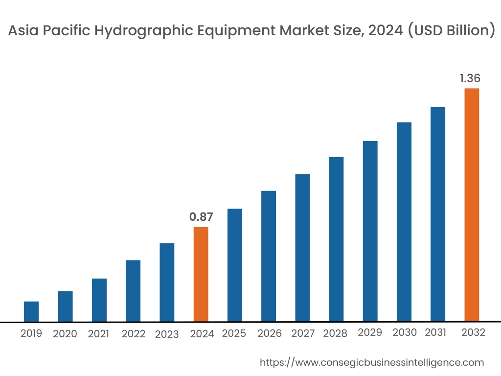
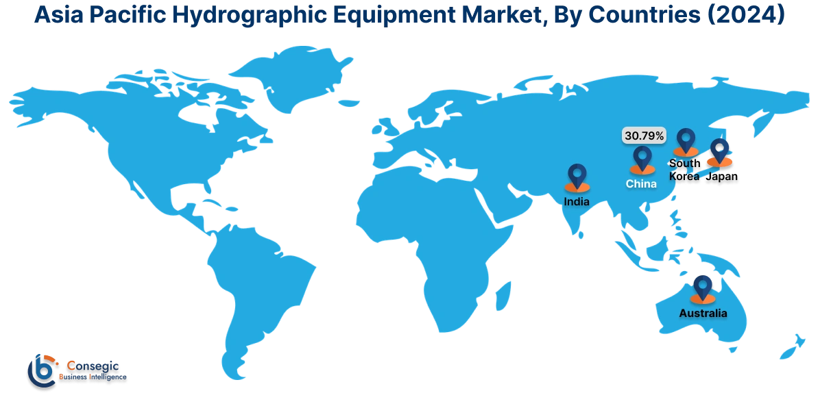
Asia Pacific region was valued at USD 0.87 Billion in 2024. Moreover, it is projected to grow by USD 0.90 Billion in 2025 and reach over USD 1.36 Billion by 2032. Out of this, China accounted for the maximum revenue share of 30.79%. The market in the region is expanding due to rising investments in military and defense sector, leading to rising adoption of hydrographic surveying equipment for various military operations. Moreover, the large coastline of the region also requires hydrographic surveying for port and harbor management, and cable and pipeline route mapping, among others.
- For instance, in December 2024, Indian Navy commissioned a new hydrographic survey ship into service. The ship named INS Nirdeshak is equipped to perform marine research and search and rescue (SAR) and to operate as a hospital ship during wartime. Thus, the aforementioned factors are driving the market growth in the Asia-Pacific region.
North America is estimated to reach over USD 1.92 Billion by 2032 from a value of USD 1.25 Billion in 2024 and is projected to grow by USD 1.30 Billion in 2025. The market in the region is driven due to well-established military and defense sector, along with the commercial applications of hydrographic surveying including navigation, port management, coastal management, environmental monitoring, and marine construction, among others.
- For instance, in February 2025, National Oceanic and Atmospheric Administration (NOAA) of U.S signed a new contract with Fugro for hydrographic survey services. The company will support the creation and maintenance of highly accurate nautical charts. The charts will ensure efficient and sage maritime navigation within US waters. Therefore, the aforementioned factors are responsible for market growth in the North American region.
In Europe, the market is driven by the rising adoption of hydrographic surveying in coastal management, safe navigation, and environmental monitoring among others. Moreover, as per the market analysis, in Latin America, Middle East and Africa, the market is primarily driven due to rising utilization of hydrographic surveying in offshore oil and gas surveying, leading to the hydrographic equipment market expansion.
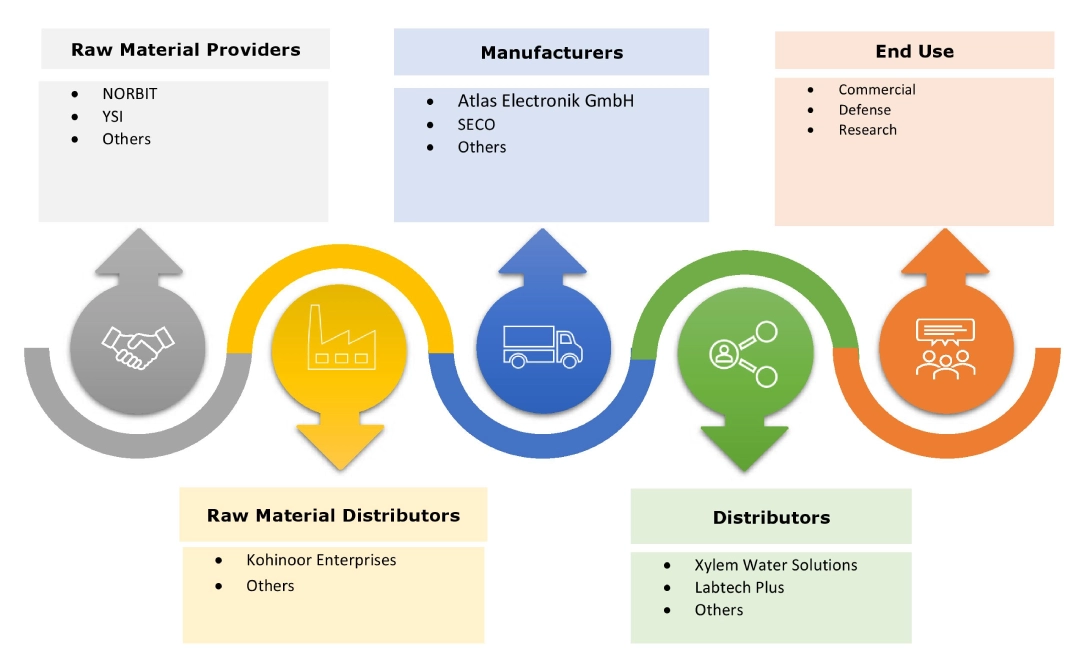
Top Key Players and Market Share Insights:
The hydrographic equipment industry is highly competitive with major players providing solutions to the national and international markets. Key players are adopting several strategies in research and development (R&D), product innovation, and end-user launches to hold a strong position in the global hydrographic equipment market. Key players in the hydrographic equipment industry include -
- Atlas Electronik GmbH (Germany)
- Hexagon AB (Sweden)
- Teledyne Technologies Inc. (US)
- Thales Group (France)
- Topcon Corporation (Japan)
- Trimble Navigation Limited (US)
- Kongberg Gruppen ASA (Norway)
- Faro Technologies Inc. (US)
- Nikon-Trimble Co., Ltd (Japan)
- Raytheon Company (US)
- Seco (Sweden)
Recent Industry Developments :
Mergers and Acquisitions:
- In March 2021, NV5 acquired Geodynamics, a provider of sonar-based, deep-water geospatial solutions. Geodynamics gives NV5 an established presence in the oceanic geospatial sector to support projects related to sea level rise, underwater habitat modeling, shoreline mapping, offshore wind power, and nautical charting.
Hydrographic Equipment Market Report Insights :
| Report Attributes | Report Details |
| Study Timeline | 2019-2032 |
| Market Size in 2032 | USD 5.34 Billion |
| CAGR (2025-2032) | 6.0% |
| By Type |
|
| By Platform |
|
| By Application |
|
| By Depth |
|
| By End User |
|
| By Region |
|
| Key Players |
|
| North America | U.S. Canada Mexico |
| Europe | U.K. Germany France Spain Italy Russia Benelux Rest of Europe |
| APAC | China South Korea Japan India Australia ASEAN Rest of Asia-Pacific |
| Middle East and Africa | GCC Turkey South Africa Rest of MEA |
| LATAM | Brazil Argentina Chile Rest of LATAM |
| Report Coverage |
|

Key Questions Answered in the Report
How big is the hydrographic equipment market? +
Hydrographic Equipment Market size is estimated to reach over USD 5.34 Billion by 2032 from a value of USD 3.46 Billion in 2024 and is projected to grow by USD 3.59 Billion in 2025, growing at a CAGR of 6.0% from 2025 to 2032.
What are the major segments covered in the hydrographic equipment market report? +
The segments covered in the report are type, platform, application, depth, end user, and region.
Which region holds the largest revenue share in 2024 in the hydrographic equipment market? +
North America holds the largest revenue share in the hydrographic equipment market in 2024.
Who are the major key players in the hydrographic equipment market? +
The major key players in the market are Atlas Electronik GmbH (Germany), Hexagon AB (Sweden), Kongberg Gruppen ASA (Norway), Faro Technologies, Inc. (US), Nikon-Trimble Co., Ltd (Japan), Raytheon Company (US), Seco (Sweden), Teledyne Technologies Inc. (US), Thales Group (France), Topcon Corporation (Japan), and Trimble Navigation Limited (US).