- Summary
- Table Of Content
- Methodology
Aerial Imaging Market Size:
Aerial Imaging Market Size is estimated to reach over USD 12.02 Billion by 2032 from a value of USD 4.72 Billion in 2024 and is projected to grow by USD 5.23 Billion in 2025, growing at a CAGR of 13.7% from 2025 to 2032.
Aerial Imaging Market Scope & Overview:
Aerial imaging refers to the process of capturing images from Earth’s surface, by using various platforms, including drones, helicopters, and fixed wing aircraft, among others. By leveraging various imaging techniques such as photogrammetry, remote sensing, and LiDAR (light detection and ranging), it provides valuable insights into terrain mapping, asset management, and spatial analysis with exceptional precision and efficiency.
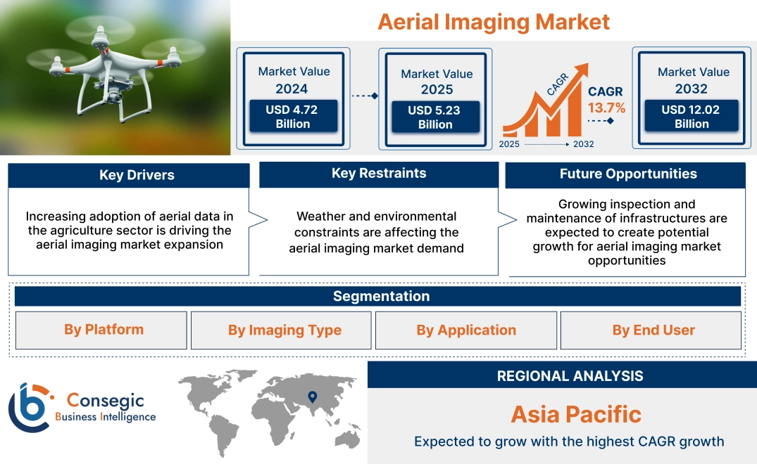
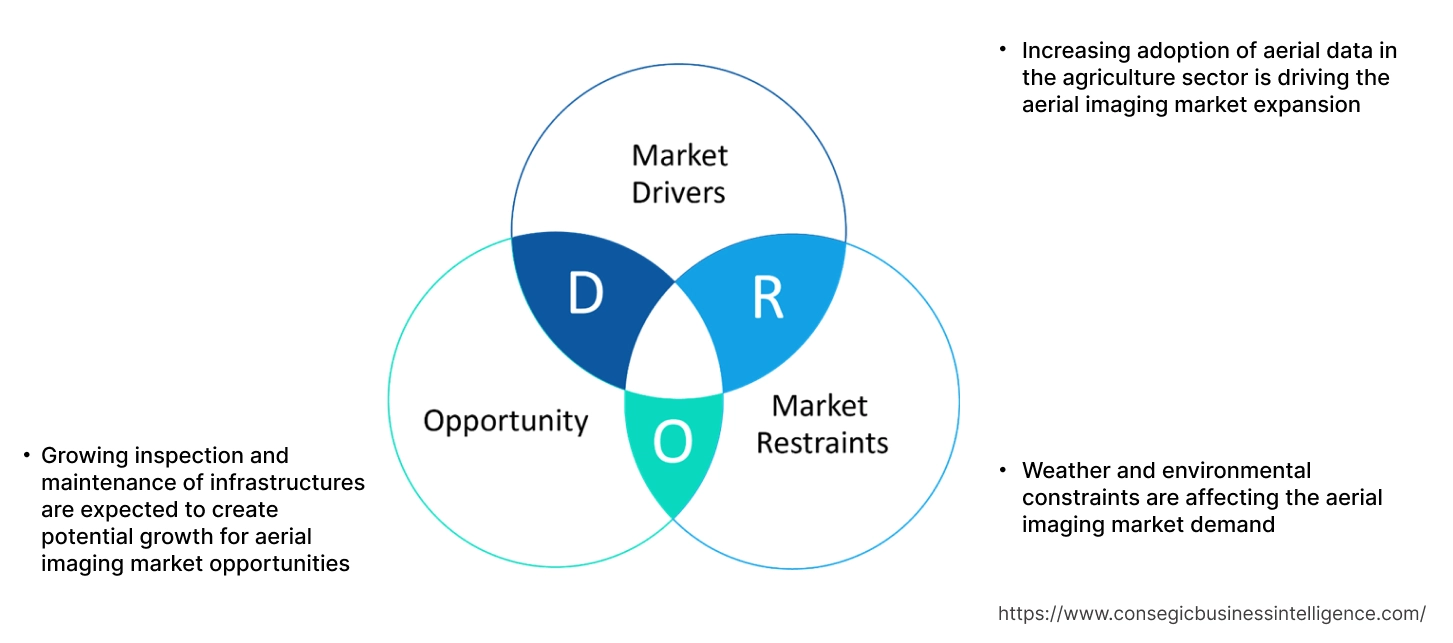
Aerial Imaging Market Dynamics - (DRO):
Key Drivers:
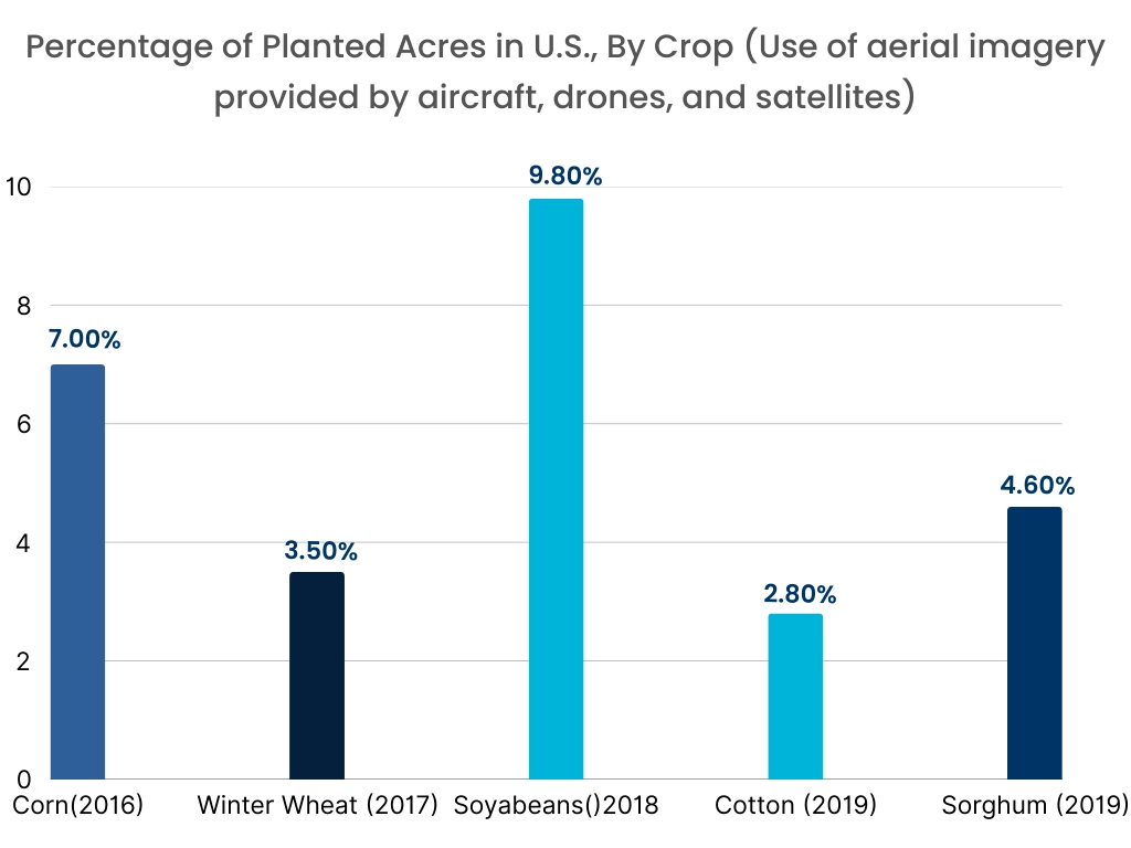
Increasing adoption of aerial data in the agriculture sector is driving the aerial imaging market expansion
The companies across various sectors are enabling the value of real-time and high-resolution data with drone-based data collection services. Aerial data, captured through advanced sensors on drones, provides organizations with insights that are more accurate and efficient. Drones offer real-time aerial views of construction sites, enabling project managers to track progress, monitor safety, and ensure adherence to timelines. Further, drones in the agriculture sector assist farmers to reduce synthetic inputs and provide targeted spraying methods that minimize chemical usage. Further, in agriculture, drones provide farmers with detailed images of crop health, enabling them to make timely decisions regarding irrigation, fertilization, and pest control.
- For instance, in February 2023, XAG announced the partnership with Farmlno, to bring autonomous agricultural drones to Thailand. The partnership will lead to the launch of autonomous drones with smart control systems. The drones are fully autonomous and powered by AI, making them extremely efficient and effective in terms of aerial imaging, precision spraying and spreading. With the aerial imagery services, farmers can gather valuable insights into crop health, soil conditions, and pest infestations, facilitating timely decision-making and precise interventions.
Thus, according to the aerial imaging market analysis, the growing demand for aerial data is driving the aerial imaging market size.
Key Restraints:
Weather and environmental constraints are affecting the aerial imaging market demand
Weather and environmental constraints significantly impact aerial imaging operations, posing challenges for industries that rely on aerial data collection. Adverse weather conditions, such as high winds, rain, snow, and fog, severely limit drone functionality and safety. Drones, particularly those used for large-scale commercial applications, are equipped with lightweight materials and may not be designed to withstand harsh weather conditions. High winds can affect the stability and control of drones, making it difficult to maintain precise flight paths. Additionally, rain and snow can damage drones sensitive equipment, such as cameras and sensors, potentially compromising the quality of the data being collected.
Further, low temperatures can reduce battery efficiency, leading to shorter flight times, while high temperatures may cause overheating of internal components. The performance of GPS and sensors used for navigation can also be compromised in areas with poor satellite coverage or in dense urban environments. Drones may struggle to maintain reliable positioning in such conditions, leading to potential safety risks and difficulties in accurately acquiring aerial images. Thus, the aforementioned factors would further impact on the aerial imaging market size.
Future Opportunities:
Growing inspection and maintenance of infrastructures are expected to create potential growth for aerial imaging market opportunities
The use of drones in infrastructure inspection enhances the speed and efficiency of maintenance activities. By providing inspectors with real-time data and imagery, drones facilitate rapid decision-making and streamline the prioritization of maintenance tasks. This proactive approach helps prevent potential failures or accidents, minimizing downtime and associated costs. Additionally, drones can access hard-to-reach or hazardous locations with ease, enabling comprehensive inspections of structures that would otherwise be challenging or dangerous to assess manually. By automating repetitive tasks and reducing the need for specialized equipment and manpower, drones help lower operational expenses and optimize resource utilization. The data collected by drones during inspections can be utilized for predictive maintenance purposes, enabling asset managers to forecast maintenance needs accurately and allocate resources efficiently.
- For instance, in August 2021, the Indian state of Tamil Nadu announced plans to employ drones in combatting illicit mining of minerals by conducting surveys and monitoring activities across approximately 1,700 quarries. The drone survey initiative is expected to require an annual investment of approximately USD 3.3 million.
Thus, based on the above aerial imaging market analysis, the growing inspection and monitoring of infrastructures are expected to drive the aerial imaging market opportunities.
Aerial Imaging Market Segmental Analysis :
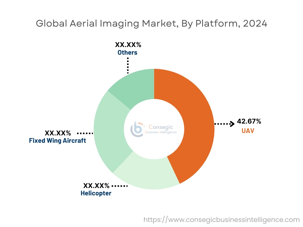
By Platform:
Based on platform, the market is segmented into fixed wing aircraft, helicopter, UAV, and others.
Trends in the platform:
- The emergence of sophisticated aerial imaging platforms equipped with high-resolution cameras, multispectral sensors, and advanced data analytics capabilities has provided access to actionable geospatial intelligence, empowering users to extract valuable insights from vast datasets with ease.
- Rising integration of AI and machine learning is enabling aerial vehicles to perform increasingly complex tasks autonomously, including navigation, obstacle avoidance, and data analysis.
- IoT integration allows drones to become part of larger interconnected systems, facilitating data sharing and coordinated operations.
- Thus, the above factors are driving the aerial imaging market demand.
The UAV segment accounted for the largest revenue share of 42.67% in the year 2024.
- UAVs/drones have emerged as a disruptive force in the aerial imaging market, offering versatility, cost-effectiveness, and accessibility. These remotely piloted aircraft have provided aerial imagery by enabling users to capture high-resolution imagery with ease and precision, even in challenging or inaccessible environments.
- Governments worldwide are increasingly allocating funds to enhance their defense capabilities and safeguard critical infrastructure from emerging threats posed by unmanned aerial vehicles. These investments are driven by escalating geopolitical tensions, evolving security challenges, and the proliferation of UAV technology among both state and non-state actors.
- For instance, DroneDeploy aerial platform enables aerial users to capture and organize photos, generate inspection reports and maps. The platform is linked with DroneDeploy ground imagery for a whole view of user assets and sites from every angle.
- Thus, based on the above analysis, these factors are further driving the aerial imaging market growth.
The fixed wing aircraft segment is anticipated to register the fastest CAGR during the forecast period.
- The rising demand for surveillance and reconnaissance missions is driving the growth of the segment.
- These aerial vehicles offer advantages such as extended endurance, high-resolution imaging capabilities, and the ability to operate at varying altitudes, making them necessary assets for modern military operations.
- Manufacturers are significantly extending operational capabilities of their aircraft, enabling longer flight durations, greater coverage areas, and enhanced mission flexibility. This is advantageous for applications such as aerial surveillance, reconnaissance, and mapping, where extended endurance is critical for mission success.
- For instance, in February 2025, T-DRONES unveiled VTOL VA32, a fixed aircraft, which is built for high payload capacity and long duration flights. The aerial vehicle was developed to optimize the tasks for surveillance, mapping, and cargo delivery.
- Thus, based on the above developments, these factors are expected to drive the aerial imaging market share during the forecast period.
By Imaging Type:
Based on imaging type, the market is segmented into vertical imaging and oblique imaging.
Trends in the imaging type:
- Governments and municipalities are heavily investing in aerial imagery systems to monitor infrastructure development, manage urban mass, and improve city planning. The integration of these systems with geographic information systems (GIS) and other data analytics platforms allows for more efficient data processing and decision-making.
- The development of software solutions that facilitate easy processing and interpretation of aerial images is further driving the segment. These software solutions incorporate artificial intelligence and machine learning algorithms, enabling automated analysis and providing actionable insights that enhance operational efficiency and accuracy.
The vertical imaging segment accounted for the largest revenue in the year 2024.
- The incorporation of advanced features, such as high-resolution cameras, thermal sensors, and AI-powered analytics is enhancing the utility of vertical imaging in various applications.
- The operational flexibility of UAVs and other drones makes them suitable for aerial imaging, particularly for applications requiring frequent or localized data collection.
- Thus, these factors would further supplement the aerial imaging market
The oblique imaging segment is anticipated to register the fastest CAGR during the forecast period.
- Oblique imaging capture images at 40-45 degrees, which provide 3D views and detailed prospective, particularly for applications like urban planning and infrastructure assessment, while providing valuable data for infrastructure management and decision-making.
- The advancement in photogrammetry and computer have enhanced the processing and analysis of oblique imaging, while making it more accessible to a wider range of users.
- These developments in the oblique imaging segment are anticipated to further drive the aerial imaging market trends during the forecast period.
By Application:
Based on application, the aerial imaging market is segmented into geospatial mapping, disaster management, archeology, construction and development, defense & intelligence, energy and resource management, surveillance and monitoring, data collection and processing, urban planning, and others.
Trends in the application:
- The solution and service providers are anticipated to gain attraction by encouraging companies to utilize UAV imagery. Further, an increasing number of organizations are seeking the UAV software and developing software to provide mapping solutions and aerial imagery services for the commercial sector.
- Governments and companies are developing drones with certain useful loads and sensors to monitor pollution, climate change and realistic biodiversity.
The geospatial mapping segment accounted for the largest revenue in the year 2024.
- The segment growth is attributed to the growing need for geospatial mapping from government agencies, urban planners’ geographic information system professionals, who are seeking precise spatial data for informed decision-making and infrastructure development.
- The advent of cloud-based geospatial platforms has offered access to geospatial data and tools, enabling small and medium-sized enterprises to leverage location intelligence for their business operations. This advancements in geospatial analytics and visualization techniques, is fostering innovation and unlocking new prospects in areas such as smart cities, precision agriculture, and disaster management.
- For instance, Phase One’s geospatial solutions include imaging software and high-resolution cameras, which enables evaluation and accurate mapping for industries, such as urban planning, agriculture, and environmental monitoring.
- Thus, based on the above developments, these factors are driving the aerial imaging market growth.
The surveillance and monitoring segment is anticipated to register the fastest CAGR during the forecast period.
- Surveillance & monitoring represent critical applications in public safety and security, where drones play a pivotal role in enhancing situational awareness, reconnaissance, and emergency response capabilities.
- The drones are equipped with thermal imaging cameras, night vision sensors, and real-time video transmission systems.
- Drones enable law enforcement agencies, firefighting units, and search and rescue teams to conduct aerial surveillance, locate missing persons, and assess disaster-affected areas in a timely and efficient manner.
- For instance, in January 2025, advanced tethered drones were deployed at Mahakumbh, Prayagraj, by Uttar Pradesh government, to enable real-time surveillance and efficient crowd management. The local government has deployed 11 drones and anti-drone systems to improve aerial surveillance and crowd control across the whole ground.
- These factors are anticipated to further drive the aerial imaging market trends during the forecast period.
By End User:
Based on end user, the market is segmented into government, military and defense, energy, construction, media & entertainment, agriculture and forestry, and others.
Trends in the end user:
- In the construction sector, drones are used for on-site inspections, progress and monitoring. Developers and construction companies use drones to capture air images at high resolution to help the development, design and tracking of construction projects.
- The growing need for drone data services for intelligence, polls and monitoring in mining sector is driving the global market. The drone provides an effective way to check and map the mining area to comply with safety and environmental standards.
The military & defense segment accounted for the largest revenue share in the year 2024.
- The military & defense sector leverages aerial imagery for reconnaissance, surveillance, and intelligence gathering purposes. Aerial imagery obtained from satellites, drones, and aircraft provides defense agencies with valuable insights into enemy activities, border surveillance, and disaster response planning.
- Advancements in aerial imaging technologies, such as hyperspectral and infrared imaging, enable military forces to detect camouflage and hidden threats, enhancing national security and defense capabilities.
- For instance, in February 2025, Garuda Aerospace launched 8 drones for defense & military operations at Aero India 2025. This progress will fuel the expansion and explore new markets, while solidifying the company’s position in drone technology.
- Thus, based on the above factors, these developments in the military & defense segment are driving the global market trends.
The agriculture and forestry segment is anticipated to register the fastest CAGR during the forecast period.
- Equipped with high-resolution cameras and multispectral sensors, drones can capture detailed imagery and data about crop growth, plant health, pest infestations, and nutrient deficiencies, allowing farmers to detect problems early and take corrective actions to optimize yields and minimize losses.
- With aerial imagery, farmers leverage real-time data insights to respond rapidly to changing conditions, optimize resource usage, and maximize productivity, leading to improved crop yields, reduced costs, and enhanced sustainability in farming operations.
- For instance, in April 2024, DJI Agriculture announced the global release of drones Agras T50 and T25. The T50 offers excellent efficiency for large-scale agricultural operation, while the T25 drone is designed for greater tolerance and is suitable for small fields. Both drones are gently integrated with improved Smartfarm applications to provide reliable and comprehensive aviation management.
- These factors are anticipated to further drive the global market trends during the forecast period.
Regional Analysis:
The global market has been classified by region into North America, Europe, Asia-Pacific, Middle East & Africa, and Latin America.
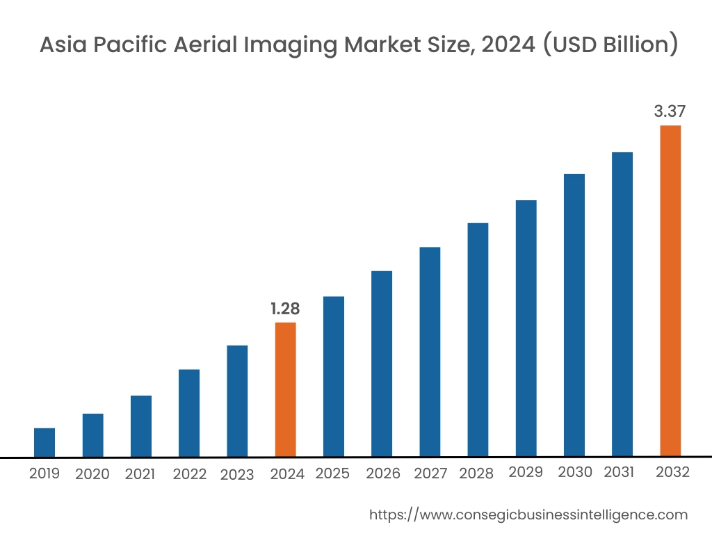
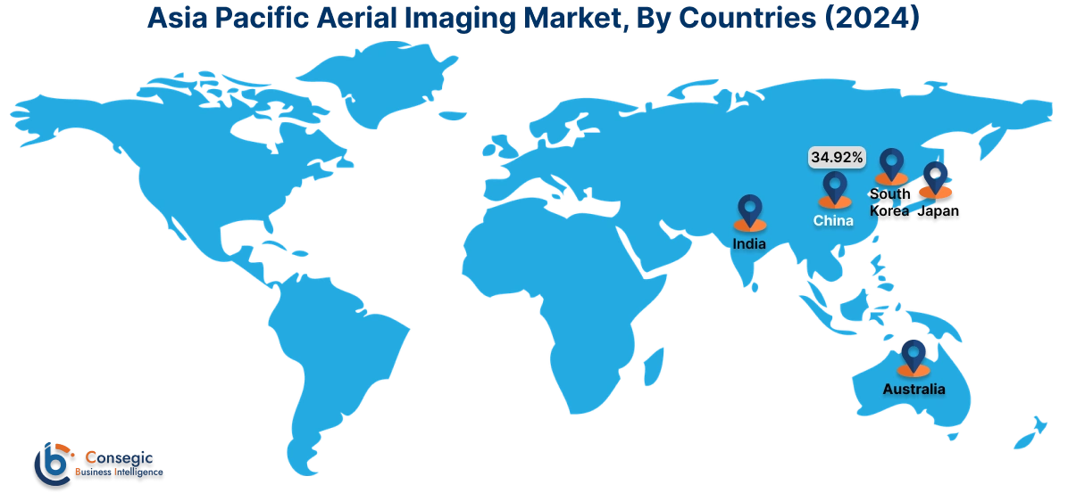
Asia Pacific aerial imaging market expansion is estimated to reach over USD 3.37 billion by 2032 from a value of USD 1.28 billion in 2024 and is projected to grow by USD 1.42 billion in 2025. Out of this, the China market accounted for the maximum revenue split of 34.92%. Countries such as China, Japan and India have succeeded in adopting aerial imagery in various sectors, such as agriculture, mining and infrastructure development. Further, the rapidly expanded market of Chinese drones combines with large agricultural applications to promote the market in the APAC region. In addition, the need for urban planning and the growing development of smart cities in the region has created the demand for aerial imagery services and solutions. These factors would further drive the regional aerial imaging market during the forecast period.
- For instance, in December 2024, Adani Defense and Aerospace has delivered a surveillance drone, Drishti-10 Starliner, to the Indian Navy, to boost the India’s maritime forces to mitigate piracy risks and monitor shipping lines. The Drishti 10 Starliner drone developed by ADANI Defense and Aerospace is a 36-hour durability and a 450kg intellectual platform for observation and intelligence.
North America market is estimated to reach over USD 4.11 billion by 2032 from a value of USD 1.63 billion in 2024 and is projected to grow by USD 1.80 billion in 2025. North America holds a prominent position in the market, driven by the presence of key players, technological advancements, and robust regulatory frameworks supporting the adoption of aerial imagery solutions. Further, the region's mature infrastructure and high demand for geospatial data across industries such as agriculture, construction, and defense contribute to its significant market share. Moreover, increasing investments in smart city initiatives and infrastructure development projects further propel the growth of the aerial imaging market in North America. These factors would further drive the regional market.
- For instance, in May 2024, Lockheed Martin announced the investment of USD 10 million in PV Labs for the development of aerial imagery solutions. The investment advanced the PV Lab’s new airborne technology, Fifth-generation Advanced Stabilization Turret (FAST). With this investment, the lab will develop variants for aerospace and defence customers.
According to the analysis, the aerial imaging industry in Europe is projected to witness significant development during the forecast period. Countries such the UK, Germany, and France are witnessing strong need for drone data services due to the growing need for precision in land surveying, infrastructure monitoring, and environmental management. Additionally, Latin America represents a growing market for aerial imagery solutions, driven by increasing investments in infrastructure development, agriculture modernization, and environmental conservation efforts. Additionally, initiatives to combat deforestation, illegal mining, and land degradation further fuel the need for aerial imagery technologies in the region, positioning the region as a significant market for regional players looking to capitalize on emerging prospects.
Further, countries such as Saudi Arabia, UAE, and South Africa are investing in aerial imagery solutions to support infrastructure development projects, natural resource management, and environmental monitoring efforts. Furthermore, the region's expanding tourism industry and growing demand for high-resolution imagery for marketing and promotional activities present additional prospects for market growth in the Middle East and African regions.
Top Key Players & Market Share Insights:
The global aerial imaging market is highly competitive with major players providing solutions to the national and international markets. Key players are adopting several strategies in research and development (R&D), product innovation, and end-user launches to hold a strong position in the market. Key players in the aerial imaging industry include-
- Google Inc. (U.S.)
- Cooper Aerial Surveys Co. (U.S.)
- Cyberhawk (U.K.)
- DJI Technology Co., Ltd. (China)
- AeroVironment (U.S.)
- Digital Aerial Solutions (DAS), LLC (U.S.)
- EagleView (U.S.)
- Fugro (Netherlands)
- Global UAV Technologies (Canada)
- Kucera International (U.S.)
Recent Industry Developments :
Partnership:
- In May 2023, Inspired Flight Technologies announced the partnership with Phase One, to introduce a modern plug-and-play solution. This innovative solution seamlessly integrates aerial photography with flexible operations to address diverse surveying and inspection requirements. The collaboration underscores the industry's commitment to innovation and highlights the potential for synergistic partnerships to drive advancements in aerial imagery technology.
Aerial Imaging Market Report Insights:
| Report Attributes | Report Details |
| Study Timeline | 2019-2032 |
| Market Size in 2032 | USD 12.02 Billion |
| CAGR (2025-2032) | 13.7% |
| By Platform |
|
| By Imaging Type |
|
| By Application |
|
| By End User |
|
| By Region |
|
| Key Players |
|
| North America | U.S. Canada Mexico |
| Europe | U.K. Germany France Spain Italy Russia Benelux Rest of Europe |
| APAC | China South Korea Japan India Australia ASEAN Rest of Asia-Pacific |
| Middle East and Africa | GCC Turkey South Africa Rest of MEA |
| LATAM | Brazil Argentina Chile Rest of LATAM |
| Report Coverage |
|

Key Questions Answered in the Report
How big is the Aerial Imaging Market? +
Aerial Imaging market size is estimated to reach over USD 12.02 Billion by 2032 from a value of USD 4.72 Billion in 2024 and is projected to grow by USD 5.23 Billion in 2025, growing at a CAGR of 13.7% from 2025 to 2032.
Which is the fastest-growing region in the Aerial Imaging Market? +
Asia-Pacific is the region experiencing the most rapid growth in the market.
What specific segmentation details are covered in the Aerial Imaging report? +
The aerial imaging report includes specific segmentation details for platform, imaging type, application, end user, and region.
Who are the major players in the Aerial Imaging Market? +
The key participants in the market are Google Inc. (U.S.), Cooper Aerial Surveys Co. (U.S.), Digital Aerial Solutions (DAS), LLC (U.S.), EagleView (U.S.), Fugro (Netherlands), Global UAV Technologies (Canada), Kucera International (U.S.), Cyberhawk (U.K.), DJI Technology Co., Ltd. (China), AeroVironment (U.S.), and others.